Guest Piece: Leslie Simpson – Joplin’s Frank Lloyd Wright Usonian House

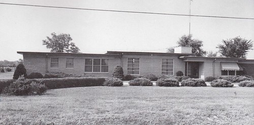
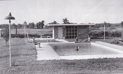
In the mid-20th century, Frank Lloyd Wright invented the concept of “Usonian” houses, which were based on the utopian ideals of simplicity, economy, and convenience. The first step in constructing a Usonian house was to lay down a concrete platform with cast-in heating pipes. Next came a grouping of brick supporting screens, creating a chain of linked boxes. The brick supports were topped by a series of flat concrete roofs, with a higher roof over the living-dining area and lower ones over the bedrooms and bath. The difference in roof heights allowed extra light to come in through clerestory window strips. Light also streamed in through floor to ceiling windows, usually overlooking a garden or pool.

One of these Usonian designs was built on the outskirts of Joplin, ¼ mile west of Stone’s Corner on Highway 171. Joplin architect Robert Braeckel adapted Wright’s plans to construct this ultra-modern dwelling for Stewart and Naomi Ruth Stanley in 1950. All steel construction supported Carthage limestone walls and large expanses of glass. Copper tubing built into the floor provided radiant heat. The ultimate in modern living, the house also featured a pool and bathhouse.

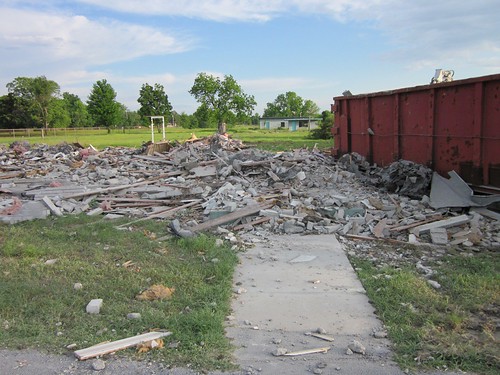
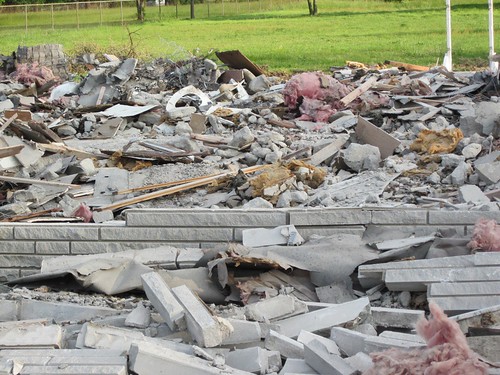
Unfortunately, I had to use past tense in my description; the house was demolished May 3, 2012. It is ironic as well since May is National Historic Preservation Month. This month’s Preservation Magazine devotes the entire issue to Frank Lloyd Wright architecture and the efforts to preserve it.


This piece was adapted from Leslie Simpson’s “Little House on the Prairie” that was published in Joplin Souvenir Album, G. Bradley Publishing, 2001. Photographs courtesy of Leslie Simpson and the Post Memorial Art Reference Library.

Leslie Simpson, an expert on Joplin history and architecture, is the director of the Post Memorial Art Reference Library, located within the Joplin Public Library. She is the author of From Lincoln Logs to Lego Blocks: How Joplin Was Built, Now and Then and Again: Joplin Historic Architecture. and Joplin: A Postcard History.

Guest Piece: Leslie Simpson – Route 66: A Method to the Madness

I have always wondered why Route 66 took such a circuitous path through Joplin.  Coming in on West Seventh, it made a sharp turn left onto Main, then headed east on First over the viaduct.  It continued on Broadway, turning north on St. Louis; after crossing Turkey Creek, it took off at a 45-degree angle on Euclid.  It went a couple of blocks on Florida, then right on Zora and left on Range Line.  If it were not for the fact that Route 66 was built during Prohibition, one might wonder if the cartographers had been a little tipsy!


Route 66 through Joplin

Recently I was looking at some old plat maps of Joplin, and I noticed something.  The Southwest Missouri Electric Railway, an electric streetcar that was established in 1893 by Alfred H. Rogers, took an identical 45-degree angle after crossing Turkey Creek in its route from Joplin to Webb City, Carterville, Lakeside Park, Carthage and other points east.  The trolley line angled through Royal Heights, a separate village that had incorporated in 1907.  Eureka!  This information may be common knowledge, but since I did not know about it, I was excited to figure it out on my own.

Plat map showing the Electric Railway line north of Turkey Creek

At its peak, the railway company operated a huge fleet of streetcars and 94 miles of tracks in three states. But its days were numbered. As private ownership of motor vehicles increased, railway patronage dwindled. In 1925, the company began running passenger buses and phasing out its streetcars.  The Joplin stretch of Route 66 was under construction from 1927 through 1932.  After Royal Heights was annexed into the city of Joplin in 1929, the railway company removed the tracks through Royal Heights. The old track-bed was paved as Euclid and became part of the historic “Mother Road.”

Guest Piece: Joplin’s Black History – Leslie Simpson

The history of Joplin from the point of view of its black population has been difficult to trace. People are probably aware that Langston Hughes was born in Joplin, but his family left when he was still an infant. There was also the infamous lynching episode and subsequent flight of black citizens in 1903. But what about those who stayed, worked, raised their children, and died in Joplin? What were their lives like?

The earliest black inhabitants of southwest Missouri were, obviously, slaves belonging to the first white settlers. The 1850 slave schedule for Jasper County listed 212 slaves, including 3 belonging to John C. Cox, who later established the town of Joplin. There were 166 slaveholders registered in the county in 1861. Slaves were itemized on county probate records and deed transfers as well. It is heart-rending to read some of these documents. For instance, there is the account of an entire family (Sarah, Mary, Henry, Lewis, Susan, and Matilda) being sold for $1 and of three “copper-colored slaves” given to Arabella Sanders by her mother Margaret as a gift.

What happened to these people after they were freed? How did they earn a living? The 1870 census reveals the few occupations that were available to them–mill work, farm labor, and housekeeping. The mining boom, which put Joplin on the map in 1872, gave the freed slaves many more options. The 1880 census indicates that they held jobs in hotels, butcher shops, saloons, laundries, livery stables, in addition to doing farm and domestic work. They also worked in the mines. In fact, some were even mine owners! The Black Seven mine was owned by seven black men.

Joplin’s population grew from 9,943 in 1890 to 26,023 in 1900. Business was booming, and there was work for all. The 1900 census reveals an interesting trend. In addition to the previously noted occupations held by blacks, there were also more skilled professions listed–teacher, preacher, physician, barber, stone mason, plasterer, coachman, ice man, carpenter, taxi driver, grocer, upholsterer, and woolen mill, to name a few. But this trend did not last, probably due to the Great Depression and to the end of the mining era. In the 1937 Negro City and County Directory the majority of Joplin’s black citizenry were porters, domestic workers, and janitors. The only black-owned businesses were a dry cleaner, shoe shine parlor, barber shop, shoe repair shop, and a boarding house.

Speaking of 1937, the introduction to the Joplin city directory for that year, written by the Chamber of Commerce, enthuses that “The population is almost entirely white and almost entirely composed of intelligent, native stock, thereby eliminating the chief source of recurrent labor troubles.”

These are merely observations based upon a few historic documents. The black history of Joplin has yet to be written.

Leslie Simpson, an expert on Joplin history and architecture, is the director of the Post Memorial Art Reference Library, located within the Joplin Public Library. She is the author of From Lincoln Logs to Lego Blocks: How Joplin Was Built, Now and Then and Again: Joplin Historic Architecture. and Joplin: A Postcard History.

Guest Piece: Chapters Erased from Joplin’s Architectural History – Leslie Simpson

CHAPTERS ERASED FROM JOPLIN’S ARCHITECTURAL HISTORY

By Leslie Simpson
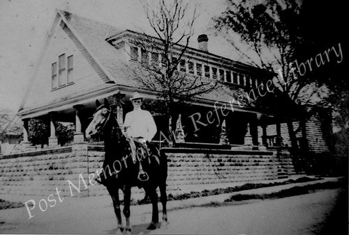
caption for photo: Carl Owen house at 2431 Porter. Built ca. 1911. Destroyed by tornado May 22, 2011 via Post Memorial Art Reference Library

I am having a difficult time knowing what to say.  In fact, I hesitate to even write anything about brick and mortar, when human life, hopes, and dreams are what really matter.  However, since I have written so much about Joplin’s architecture through the years, I feel compelled to say something.  I have had several CNN reporters contact me for interviews, but I have not wanted to talk to them.  First of all, I had not personally seen all the damage.  It is impossible to get around, and I did not want to get in the way of emergency workers nor be a voyeur.  Secondly, I just did not think I could articulate what has happened to my beloved Joplin.  So now I will attempt some general (and unofficial) impressions of Joplin’s historic identity and how this incomprehensible tragedy has affected it.  Also, rather than catalog specific buildings that have been lost, I will focus on three historic residential areas.

I begin with the historic town of Blendville in southwest Joplin, which was established in 1876 as “Cox Diggings.”  The prosperous little community incorporated as Blendville, so-named because of the huge amounts of zinc blende in the ground.  Thomas Cunningham owned the residential area, which he divided into lots and sold at low rates so that miners could afford their own homes.  The city of Joplin extended its streetcar line to Blendville, with lines going south on Main to 19th Street, west to Byers, south to 21st Street, west to Murphy, then south to 26th.  In 1892, Joplin annexed the village.  Thomas Cunningham donated “Cunningham Grove” as Joplin’s first city park.  The tornado took out most of the original Blendville area, including Cunningham Park and the historic water plant with some of the original equipment preserved inside.


The next area of historic significance is “Schifferdecker’s First Addition”, a residential area developed in south Joplin beginning in 1900.  The Joplin Globe referred to the area lying south of 20th Street and fronting on Wall, Joplin, and Main Street as “a beautiful new addition affording the most desirable building property” to be found anywhere in the city.  A second addition continued development south of 20th on Virginia, Kentucky, and Pennsylvania Avenues as well as along 21st, 22nd, and 23rd Streets to the east and west.  The residential district continued to expand to the south throughout the teens, twenties, thirties.  The homes in the region ranged from high Victorian styles to bungalows and eclectic Tudors, Colonial Revivals, Spanish mission, etc.  Tragically, this charming old neighborhood has been wiped out.

After World War II ended, Joplin families faced a housing shortage.  Some Camp Crowder buildings were moved to Joplin, while others were dismantled to provide construction materials.  Hundreds of small efficiency houses were mass-produced for veterans and financed through FHA.  Many of these were built in the Eastmoreland area.  As people prospered in the 1960s and 1970s, they built more substantial brick homes east and south of the new high school at 20th and Indiana.  Although most people do not think of these homes as historic, they do have their own place in Joplin’s architectural history, and their loss is devastating as well.

Entire chapters of Joplin’s history have been forever erased.  I have not even touched on the loss of churches, schools, medical buildings, and businesses.   Again, I am not relating the loss of our buildings to the loss of our people.   Joplin will rebuild.  It has already begun.   During the first week after the tornado, I saw a business being rebuilt in the midst of the war zone surrounding West 26th Street!
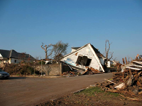
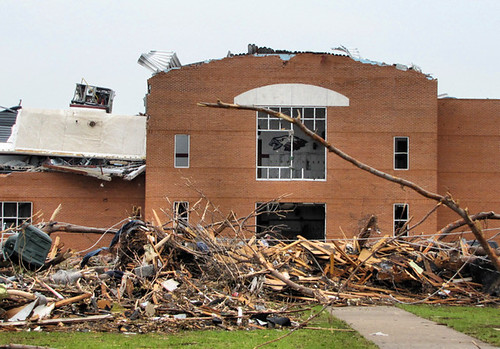
Porter House following Joplin Tornado. Photo by Leslie Simpson
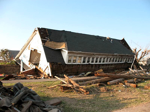
Porter House following Joplin Tornado. Photo by Leslie Simpson
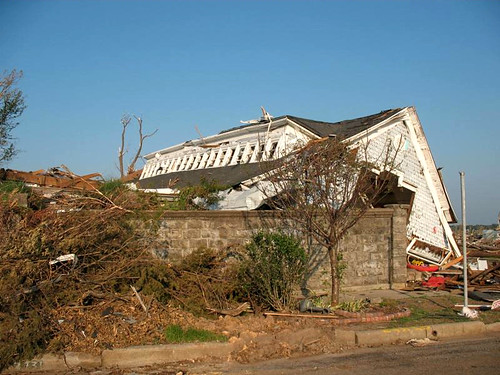
Porter House following Joplin Tornado. Photo by Leslie Simpson

Leslie Simpson, an expert on Joplin history and architecture, is the director of the Post Memorial Art Reference Library, located within the Joplin Public Library. She is the author of From Lincoln Logs to Lego Blocks: How Joplin Was Built, Now and Then and Again: Joplin Historic Architecture. and the soon to be released, Joplin: A Postcard History.
Guest Post: Down Not Out – Leslie Simpson

DOWN NOT OUT

By Leslie Simpson

On a pleasant Sunday evening, May 22, 2011, an EF-5 tornado suddenly raged through densely-populated south Joplin.  It destroyed almost everything in its path for 13.8 miles in distance and up to a mile in width.

The tornado smashed down in southwest Joplin, wrecking residential areas, Cunningham Park, schools, medical offices, and a major hospital complex, St. John’s. It headed east, obliterating untold acres of late nineteenth and early twentieth century houses.  The storm’s wrath intensified as it forged east, razing businesses along Main Street, more neighborhoods, and Joplin High School.  It wiped out much of the lifeblood of Joplin’s economy, the commercial strip on Range Line Road, then rampaged on, demolishing housing, banks, industrial buildings, and more schools and churches.  It finally dissipated east of Joplin, after destroying or damaging an estimated 8,000 homes and businesses.

At the time of this writing, authorities have confirmed 138 fatalities, a number which continues to rise.  More than 1,150 people sustained injuries.  The Joplin tornado, the deadliest since modern record keeping began in 1950, ranks eighth among the deadliest tornadoes in U.S. history.

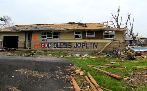
We are in shock.  We drive familiar streets yet cannot even recognize where we are.  The cruel landscape of endless rubble and shredded trees reminds us of shattered lives and endless grief.  We have lost so much, and we are hurting on many levels.  But our spirit is strong, as evidenced by the person who spray-painted “Down not out” on the shards of his former home.

Leslie Simpson, an expert on Joplin history and architecture, is the director of the Post Memorial Art Reference Library, located within the Joplin Public Library. She is the author of From Lincoln Logs to Lego Blocks: How Joplin Was Built, Now and Then and Again: Joplin Historic Architecture. and the soon to be released, Joplin: A Postcard History.